Saturday, July 30, 2011

Last Day: Hachita to Antelope Wells Mexican Border Crossing


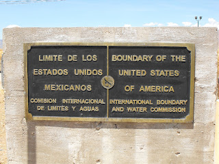
45 miles to go, all on pavement, 90 something degree weather, no water sources, no trailer. My shadow was seen at 7ish in the morning, Sam stepped out since he is usually up around 5. There was a pot of coffee on, and Bear was wide awake. If filled my water bottles and packed my backpack with essentials for the next 45 miles. Same guessed that it would take 4 hours, and I set off around 8am down route 81 possibly the loneliest paved road in America. It took a little adjustment to get used to bike without the trailer, and trying to keep the speedometer above 12mph. Most of the traffic was border patrol, I was soon the the Hachet Wildlife area and took a short break for breakfast. Not long after I spotted my first tarantula! jumping off the bike and breaking out the camera! At around 11pm the same old truck pulled up beside me with 15 miles to go. I mentioned that this was similar to playing hide and seek, saying that you would count to 20 but you only counted to 10. Sam had left an hour early but he and Bear we happy to rest at the border. I reached to border in just over 4 hours and saw Sam asleep a couple 100ft from the border. He had mentioned that he knew the border patrol and I went into the office to say hi. I was offered a congratulatory popsicle and the vending machine was opened for me to grab a soda. After a couple pictures and breathes at the border, I rode back to Sam and we headed to pack up my gear before heading to Las Cruces. It was a finally over, the long awaited journey had come to fruition and was now at its terminus. Thanks to all of those that have supported me and helped Vets Helping Heroes. We will see what adventure is next!
Separ to Hachita


After being in contact with "trail angel" Sam Hughes while in Silver, today was a short ride mostly on pavement to the town of Hachita, 28 miles or so. I restocked at the Continental Divide store in Separ and set of paralleling I-10, this would lead to 146 and straight south to Hachita. The barely noticeable but last crossing of the Continental Divide was along this route. It was very early when I arrived and I stopped by the post office to inquire about Sam. The lady offered water and coke and said that he only lived a couple houses away. I chose to venture towards the gas station since it was mid afternoon and I would wait a couple hours to knock on Sam's door. After an hour or so and elderly gentleman drew up in and old pickup and asked if I were looking for Sam. I validated his question and he introduced himself and his dog "Bear" or "The mighty bear dog" who will go a bear hunting at the the flick of a switch. The mighty bear dog greeted me, and I was invited to follow Sam to his house. Once there I set up my tent while Sam and Bear sat in the shade and watched me work. After completion of my abode, I was offered a "whiskey drink" since Sam had just procured the ice and we went inside to share some stories. Sam left to spend some time with his friends in Hachita, and I went out to set up the rest of my gear. We laid plans for the morning and I went to sleep with a high winds a whipping.

Friday, July 29, 2011

Silver City to Separ

Southward from Silver the terrain is fairly level, I visited the supermarket and thought nothing of the ensuing 30 miles. The initial 20 something miles took me through downtown Silver, and a half hour conversation with a elderly gentleman at the local bank. Soon after I was spinning down highway 90, taking a break to take in the scenery and eat some dried apples. To my south was the vast expanse of the Chihuahuan Desert, the driest place I will have visited since that unfortunate stint in the Wyoming Basin. Shortly after I would soon be racing along this landscape, through the tall forests of Yucca and thoroughly enjoyed the dirt road over the previous pavement, average speed was around 12 miles and hour and the wind was on my side. Even though this is thorn country I only ventured of the trail once in search of water and was soon at the middle of nowhere campsite called "High Lonesome". In fact this is not a "campsite", not that I expected one, but a pick your own spot on the side of the road. Since it was only 3pm I choose to venture on towards Thorn Ranch and finally Separ. I continued to enjoy the dirt road and it was a relatively short 20 miles onward to Separ. Temperatures were in the mid 90's although did not seem to bother me as much as they had. Although at the time I did not know it, my weight had dropped to 142, reminiscent of junior year in high school. They isn't much in Separ, in fact its really only a general store. But it had plenty of calorie rich delights and offered a teepee as lodging. An early night with lots of bugs and the sounds of tractor trailers.

Wednesday, July 20, 2011

Black Canyon Campground to Silver City


I knew that it would be a long day as it was still raining when I awoke. And therefore I decided not to leave the tent until the rain had stopped. Thankfully this was around 8.30 and I set off down the embankment in search of water to fill the bottles for the ensuing climb. A series of uphill switchbacks greeted my morning stupor and I reached the pinnacle of the climb some hour or so later. This lead to a 8 mile descent and no matter what side of the dirt road I chose, there were still washboarded rivets. Not a problem if I had not shut off my front suspension, otherwise I could not wait for the road to lead to pavement. It was somewhat exciting that this would be the last real climb and descent that I would see, but also relieving and disheartening at the same time. When I met the junction with the pavement, I chose to follow the 2010 route to Silver and not the updated route which would have initially taken me north or "right". I not sure which would be longer or more difficult but both should be similar terrain. The following 30 or 40 miles followed tarmac, passing huge mining companies and tiny little towns all the way into Silver. Granted there was a huge climb in the midst of this, it was a on pavement and there was a huge shoulder to take breaks on. On arrival in Silver I quickly found a place to rehydrate and refuel as well as spend the night. Only three riding days left from here....

Thursday, July 14, 2011

Collins Park to Black Canyon Campround


Today's mileage added up to close to 60 miles, since I was short yesterday. The ride started in a Pine Timbered setting, it then passed through grasslands reminiscent of Montana, finishing in the rugged and arid Mogollan and Black Mountains. The gravel roads led to a roller-coaster of physical pain, with narrow and serpentine washboarded trails. I restocked water and had a soda at the Beaverhead Works Center, before setting out towards the Black Canyon. I was unsure whether or not I could make the designated campsite for the night and had the choice to camp early at the Wall Lake Campground. I chose to for go this option and push it until I made my mileage for the day. At around 7pm it started to thunderstorm and that last hour of my ride was very wet to say the least. The Forest Service campground was actually closed when I arrived so I had to wilderness camp on the side of the road again, thankfully there was a water source nearby so that I could stock up for the ensuing day. It was an extremely long days with about 11 hours of riding but I was glad to make up the distance and be back on track.

Valle Vences Campground to Somewhere near Collins Park


Yesterday was a fairly short 30 miles, today would be closer to 45 miles. The morning started with a simple downhill, although the terrain was slow and rocky. This placed me on Route 12 and in need of water. Thankfully it was a Sunday and the local church (the only thing around) was lively and I stopped in for water. This lead to joining the whole service, meeting the whole of the congregation and joining them for their pot luck lunch. Easily rivaling any ramen noodle concoction that I can make late at night on the trail. I bid farewell around 1pm and set off across the road into the barren plains, heading towards the Gila. Although this has become a monotonous affair it does have perfect timing and I was soon stuck in another thunderstorm. Many of the congregation passed me at this point although I mentioned that I would just wait out the storm and see how I faired. It was a long ride to find a wilderness campsite on the side of the road, but I camped 7 miles short of the designated primitive campsite. Right before this I passed the 24th crossing of the Divide.

Pie Town to Valle Vences Campground


Pie town signifies many things other than pie, it all signifies the last and final ACA map (6 of 6), it signifies only 305.5 left to go and also a 4 days stretch with no services. It starts by winding through a corridor of National Forest Lands, skirting the barren plains of the San Agustin and then ventures into the Gila National Forest, whose watershed divides are so tightly packed, which can only mean one thing. Not that this can't be seen by the numerous switchbacks shown on the maps, rattling the nerves and soon the bike. I was not looking forward to the immoderately steep climbs nor descents but off I went. I had met the "caboose" of the Tour Divide while enjoying my slice of pie and has set out late (1pm) from Pie Town just so that I could enjoy that slice. The racer has soon caught up to me in a very familiar position, sitting under a tree on the side of the road, sheltering from a thunderstorm. Although the road was in decent shape, the rain quickly made it impassable. Not only had I spent time sitting out of the rain, but then I spent another half hour going 50ft. I have not experienced the infamous mud before, but it quickly bound around the drive train and at one point I couldn't actually see my tires! There was at least 2 inches of mud/clay surrounding the tires, and a wedge of dirt stuck in the fender of the BOB. Physics students take note, simple machines really do work, just not to my advantage in this case. The other racer had an equally difficult time and we pushed through to slightly drier ground, a better choice than staying put. Although this entailed pushing the bike with one hand and scraping the mud off with another. There was a single windmill along the way and I pulled into the campground close to 7pm after a short climb to third continental divide crossing of the day (and 23rd for the trip). Although there was mention of water in the campground there was none, although I met two motorcyclists that had just started NOBO on the GDMBR. They were able to spare some water and we shared stories until it was time for me to rest.

Wednesday, July 13, 2011

PIE Town

Pie town....Pie-0-neer Cafe...self explanatory and delicious!

Grants to Pie Town


Today I chose the initially paved Malpais Alternate, this did offer one reliable source of water and my first experience with a windmill. These windmills are the only source of water available for cattle and thus allows ranchers to maintain a herd in this arid environment. Since I have never seen one before, I approached it nervously until I had figured out its mechanics, now we're good friends. This route took me past the El Malpais National Monument and La Ventana Natural Arch, both spectacular views and mini side trips. Once I turned off the paved road I started to see the daily thunderstorms roll in, each one starts with wind and then an exponential increase in rain. Unlike many other parts of the route there is no cover in this stretch so I sat on the side of the road in the rain for half an hour. Rather risk sitting in the middle of nowhere then riding a lightning rod through the desert. Two lights in the distance led to a fellow teacher from Texas rescuing me from the rain and helping me with the last 10 miles. On arrival to Pie Town, I asked for the RV park which had been recommended to me in Platoro, although it didn't seem to exist. Instead I was offered the "Toaster House" owned by a women named Nita. It took me a while to understand the concept that there was a free house with a stocked fridge of pie's and beers, running water and electricity that was open to CDT hikers and GD riders alike, but I took full advantage of a sturdy roof and had a good nights rest.

Thursday, July 7, 2011

Cuba to Pueblo Pintado


From here to Grants it 116 miles, this can be either two or three days. I chose to head to Pueblo Pintado, with little information of nearby services or surroundings. The ACA maps were not 100% accurate as far a services but it wasn't a bad stretch. The first gas station was located at around 30 miles and it was also my first meeting with someone from the "res" or member of the Navajo, he questioned whether or not Connecticut was a state but we had a great conversation as I stopped to refuel and rest the legs. Another 25 miles led to a small laundromat, and another conversation with a member of the Navajo, who asked whether or not I knew of the Mohegan Tribe. I replied that I was only aware of their $10 blackjack tables. We both had a soda and he mentioned that Pueblo Pintado was just not to far away and that their water tower was actually visible in the distance. There wasn't much to the town and I set up my tent in front of their gas station which was located right off the main road. It was a warm night but I would soon be up early to get a head start on the weather.

Chama to Cuba


Cuba or Coo-ba was a 65 mile stretch, predominantly on black top, which actually isn't too helpful when its over 90 degrees outside. It was a long ride to reach the El Vado reservoir where I poured out my remaining water bottles only to fill them again with colder refreshment, not matter how cold it doesn't take long for them to warm up again. I then entered the 16 mile off road stretch which was near unbearable. The mid day heat and dusty roads kept my legs spinning and mind set on seeing pavement again. The town of Regina offered no services since it was July 4th, and then it was a quick 12 miles to the town of Cuba. Thankfully there was a McDonald's located in Cuba, I was rather hoping for a Sonic since I had seen one in Salida, but a belly full of calories is happy either way. 5 miles from Cuba I stated to see and feel the effects from the Los Alamos fires (see pic below!), it was certainly harder to breath and the whole of Cuba was covered with smoke. Thankfully it had settled by the next morning.

Platoro to Chama


For both racers and divide riders alike, due to the recent fires near Los Alamos the route has been changed, mostly following the predetermined ACA alternates. Although I could have chosen to follow Micheal McCoy's advice to camp at Elk Creek Campground I choose to pedal all the way to Chama. Unknown territories and unknown adventures awaited. The days started following a forest road along "Rabbit" River, until..it started to rain, which lead to hail. The only hail storm in the entire state of Colorado. This meant a layover underneath a favorable pine tree. At least it was not as painful as the one I went through on the way to Butte. A quick stop on the way to Horca for a warm cup of coffee and then it was on to battle La Manga pass, otherwise known as a five mile climb which takes about an hour an a half with a BOB trailer. Due to a later start I hit the heat and slowly moved on to Cumbres Pass, thankfully this pass sat at a similar elevation and I reach it without even knowing. I did not pass a train on the Cumbres and Toltec Railway which was initially laid in the 1880's. Although I am pretty sure that the railway station does make an appearance in the Ride the Divide documentary. From there is was a lengthy but downhill coast, reaching speeds of 40mph and loving every minute of it. Ones legs can often goes to sleep at this time and they rarely cooperate afterward. Either way, I passed the welcoming signs to the "Land of Enchantment" and closed in on the town of Chama. Eager to eat and sleep after a lengthy 50 mile day.

!!!!!!!!!!!!!!!!!!!!!!!!!!!!!!!!!!!!!!!!!!!!!!!!!!!!!!!!!!!!!!!!!!!!!!!!!!!!!!!!!!!!!!!!!!!!!!!!!!!!!!

Monday, July 4, 2011

Del Norte to Platoro


Today started will 11 miles on pavement, and then a 12 mile climb to the highest peak on the divide. Indiana Pass, also known to locals as Grayback Pass is located at 11910ft which meant a 4000ft climb most of which takes part on gravel forest roads. On the way up I was fortunate to meet a buddy of Mathew Lee who helped out with the first five miles. I was soon overtaken by a divide racer and reached the top within 3 hours. From here there was a short climb to the abandoned town of Summitville and then downhill towards Stunner Campground, the designated rest stop. I chose to push further on which meant another climb of 4 miles to Stunner Pass and then coast on down to the town of Platoro. Even though I have stocked food for 4 days, there was another campground located here. I chose to camp in the RV park and was treated to a huge plate of ribs, potatoes, slaw, apple pie and a Coors Light. Enough food for at least 3 people. Although today's mileage hit the 50 mark, the roads were in decent shape, although I would often find that the dust kicked up by passing vehicles became it little irritating. A shower and good night sleep would lead to a late start tomorrow as I figure out the route from here, starting by paralleling the drainage basin of the Conejos River.

Sunday, July 3, 2011

Update !

At the moment I am in limbo, will start out of Platoro today and head on the GDMBR to Horca. The goal is now to get to the border and not necessarily by way of the GDMBR. After talking with other past divide riders here in Platoro, we have set a different route to the border due to the wildfires along the route. So from now it is an adventure. So keep track of the GPS and we will see where it goes! Its looks like going through Sante Fe is the best the best option and then reconnecting with the GDMBR in Silver City, possibly resuplying in Lordsburg before the desolate stretch from Route 10 to the border. Next stopping point will be Chama or Abiquiu. Let the adventure begin..